SINDH IN KASHMIR
A 108km long river in Ganderbal district of the Indian-administered Kashmir is called Sindh River and the entire area is known as Sindh Valley.

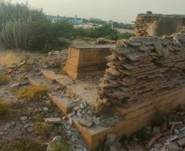
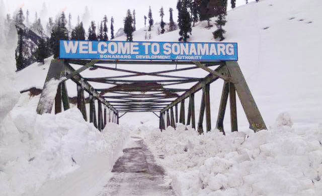
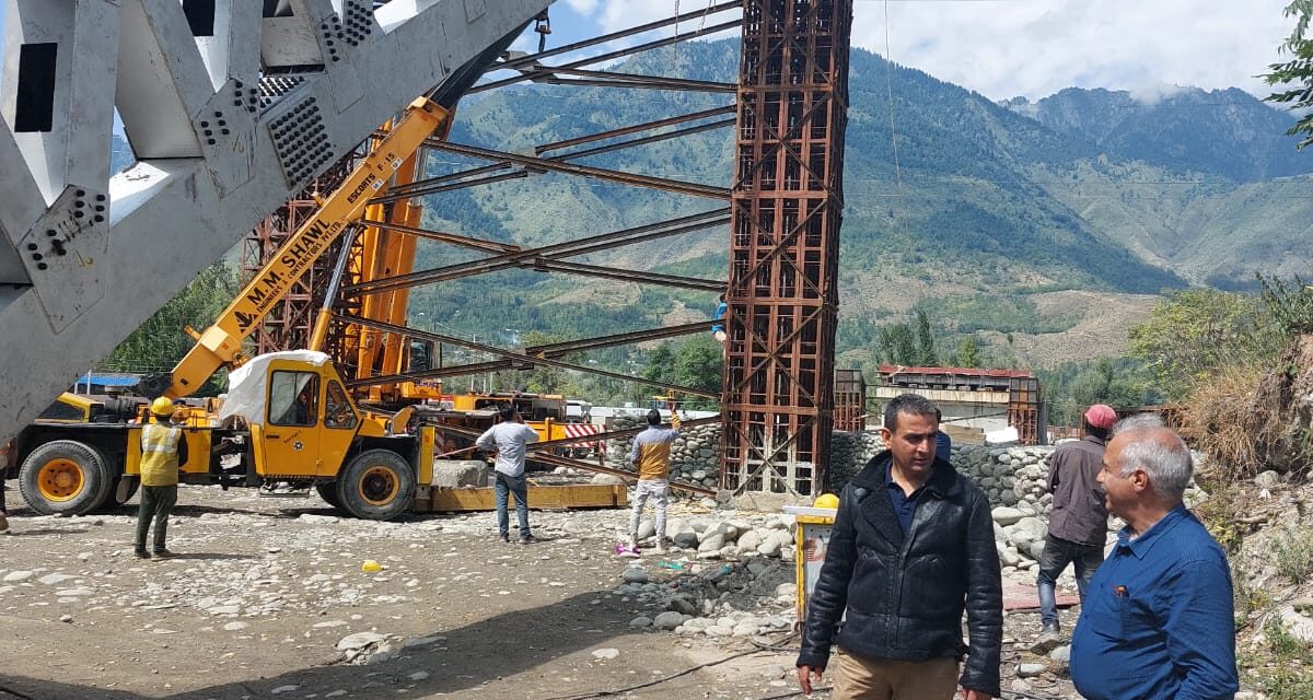
A bridge over Sindh River is also called the Sindh Bridge. The original wooden bridge at Sonamarg, damaged in 1990s, was replaced with single lane steel bridge, which too is being rebuilt having 2 lanes.
Ernest Frederic Neve (1861-1946), a British surgeon, Christian medical missionary, and author, who provided medical care to the people of Kashmir, has described Sindh Valley as ‘one of the finest and most magnificent pieces of scenery in the world.’
By Nasir Aijaz
In 2020, when the lockdown was imposed subsequent to the outbreak of Covid-19, like many other people, I had no option but to give up social life – as had been suggested to maintain social distance being part of preventive measures.
Family members were my only companions besides books, and the internet for searching the literature available online. Living a life in seclusion would have been miserable otherwise, as I would say, it was self-imposed ‘Solitary Confinement’. So I spent most of the time surfing Google and reading the online literature. It was the time when I found some information on websites about the Sindh River, Sindh Valley, and Sindh Forest, and some educational institutions having this name in Indian-administered Kashmir. Being an interesting subject for me, I had taken many notes in my diary.
At first I was confused but later it was quite amazing that the Sind (h) River and Sind (h) Valley of Kashmir were different than the Indus River, known to the world as Sindhu, and Mehran River. Similarly, it had been a general perception that the entire area covered by Indus Civilization, is the Indus Valley or Sindhu Mathri, as called in Sindhi language, but to my surprise, there exists Sindh Valley in Kashmir where the Sindh River flows.
The Sindh River of Kashmir is distinct and different from the Sindhu of Ladakh, which is today synonymous with the Indus River. However, in the ancient times the present Sindh River of Kashmir, was considered to be one of the principal sources of origin of the Sindhu or the Indus by the locals.
What tempted me to write this blog on the subject after over two years is a photo that I found a few days back with a caption, “Small village with old wooden house near Sindh bridge at Sonamarg area and was a gateway on ancient Silk Road along with Gilgit connecting Kashmir, India with Tibet Autonomous Region of China.” And this picture led my search to a brief news item according to which a new World Bank-funded arch-truss bridge is being built over Sindh River, locally called as nallah Sindh in Ganderbal district of Kashmir, and its completion is expected by December this year. The project is aimed to ease travel on Srinagar-Leh Highway in Wayil area.
It was the same place where old Sindh Bridge existed, and I had taken note of earlier. As the old single-lane steel bridge over the nallah Sindh in the Ganderbal district connecting Srinagar with Leh was causing frequent traffic halts, the authorities had started work on permanent two-lane new bridge. The single-lane steel bridge was constructed over two decades ago after the old wooden bridge got damaged due to floods in 1992.
Tourists used this bridge to visit several famous tourist and pilgrim destinations including Sonamarg, Naranag, and Amarnath shrine. Besides, thousands of other people travel on this route every day.
The Sindh River, a major tributary of the Jhelum River, originates from Machoi Glacier at an elevation of 4800 meters, foothills of holy Amarnath Cave.
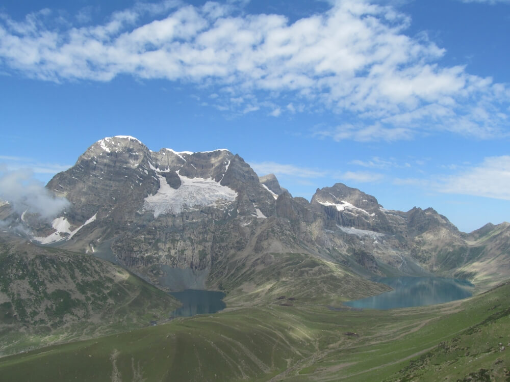
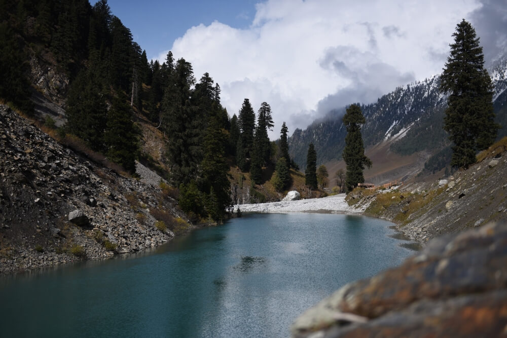
Sonamarg is the part of Ganderbal district, and it means ‘Golden Meadow’ for the snowy mountains against a cerulean sky. The Sindh River, having a length of 108 kilometers meanders along here and abounds with snow trout fish. From Sonamarg, trekking routes lead to the Himalayan lakes of Vishansar Lake, Krishansar Lake, Gangabal Lake and Gadsar Lake, stocked with snow trout and brown trout, and surrounded by banks of alpine flowers.
The Sindh River, a major tributary of the Jhelum River, originates from Machoi Glacier at an elevation of 4800 meters, foothills of holy Amarnath Cave.
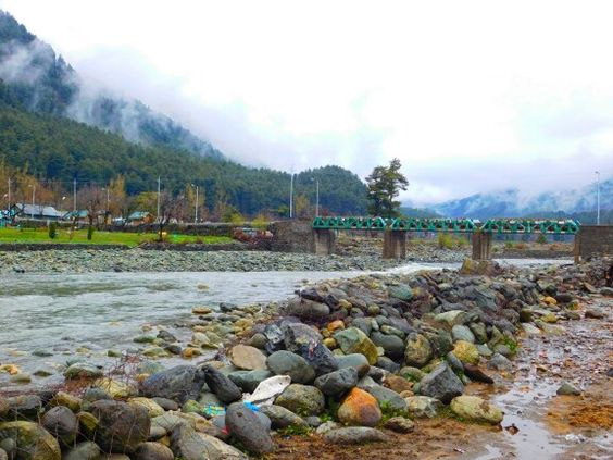
While travelling from Srinagar, after around 40 kilometer, one will first meet this river flowing under a steel bridge. From here onwards, this river will accompany along National Highway. At some places, the river flows at the level of the road, and at places, it will be visible deep down at beautiful valley, where many tributaries join the river, causing it to swell. In all sense, Sindh River amazes and thrills the visitors by its many forms. The people also do rafting in this river.

An Indian Army Officer Brigadier Ashok Abbey writes in an article that located some 53 km north of the capital Srinagar, enclosed in the folds of high mountains and exceptionally god gifted, Sindh Valley is no ordinary valley. Emerald colored lakes, mountain streams strewn with dense pine forests, high mountain passes crisscross by fascinating mountain trails and snow clad peaks, indeed make this valley special. “Delicately crafted, as if by nature herself and drained by the fast flowing pristine waters of the Himalaya, this is the Sind river valley of Kashmir,” he remarks.
As regards Sindh River, Brig. Ashok says, “The Sindh River of Kashmir is distinct and different from the Sindhu of Ladakh, which is today synonymous with the Indus River. However, in the ancient times the present Sindh River of Kashmir, was considered to be one of the principal sources of origin of the Sindhu or the Indus by the locals. Geographically, the waters of both the rivers have nothing in common, neither their riverine course nor the civilizations they support. The confusion with regard to their names is historically interesting.”
He also quotes Stein, Wilson and some other European writers according to whom it is customary in Kashmir to distinguish the two rivers by giving the designation of ‘the Great Sindh (Bud Sind),’ to the Indus. This is found as ‘Brhatsindhu’. The identity of the two river names has led to a great deal of confusion in geographical works down to the beginning of the present century. The Sindh River of Kashmir was elevated to the rank of one of the chief sources of the Indus, or else represented as a branch of the great river taking its way through Kashmir. They also mention certain maps of 1670 and 1825, saying that Sindh River is not improbably a branch of the Indus.
The Sindh valley lies in the Kangan tehsil, of newly created Ganderbal district of Kashmir, with its headquarters at Ganderbal on the outskirts of Srinagar. The valley earlier formed part of the erstwhile district of Lar or Larpargana (the ancient Lahara or Lar, was then one of the main sub divisions) and formerly covered two tehsils of Srinagar district i.e. Ganderbal and Kangan. The district has an average elevation of 1616 m and covers the entire Sindh valley. The valley is bounded by the Lidder valley to its south, the Kishanganga valley and Tilail to its north. To the northeast lies Ladakh and to the east lie the Sainnala, Bat Kol and the Warwan valley of Kishtwar.
The Gazetteer of Kashmir also describes the Sindh valley as follows:
The name of a long and narrow valley opening into the north side of Kashmir, a few miles north-west of the city of Srinagar. It extends from the village of Ganderbal, in the Larpargana, which comprises the whole of the lower portion of the valley, to the Zojji-la pass on the east, a distance of about 93 km; its breadth varies from a few hundred yards to about half a mile. It owes its name to the river Sindh, which rises in the mountains at the eastern extremity, and near the cave of Amarnath.
On either side are lofty mountains, whose tops are usually covered with snow, whose sides, more or less precipitous, are clothed with large forests of pine, and whose feet are lined with walnut, chestnut, and many other kinds or trees.
The Sind valley, apart from being bestowed with exceptional beauty, is also of strategic significance as the National Highway to Ladakh, runs through it. In the earlier times too, it was the highway and the main trade route between Kashmir and Central Asia.
The climate of this valley is considered the healthiest in Kashmir and it is a favorite resort for the upper classes of native society during the months of July and August; its fruits also, especially the grapes, are very highly esteemed.
The Gazetteer further states: “The Sindh River is the largest of the rivers of Kashmir after the Jhelum, which drains into the Vyath or the Vitasta, the original Sanskrit name for the present Jhelum. Even today, waters of the Sindh River link with famous lakes of Dal, Anchar and Manasbal. It is interesting to note that Jhelum, as the river Vitasta is called today, was earlier unknown by this name in Kashmir. The Sindh River contributes more water to Jhelum, than any other river including its southern neighbor, the Liddar.”
The Sind valley, apart from being bestowed with exceptional beauty, is also of strategic significance as the National Highway to Ladakh, runs through it. In the earlier times too, it was the highway and the main trade route between Kashmir and Central Asia.
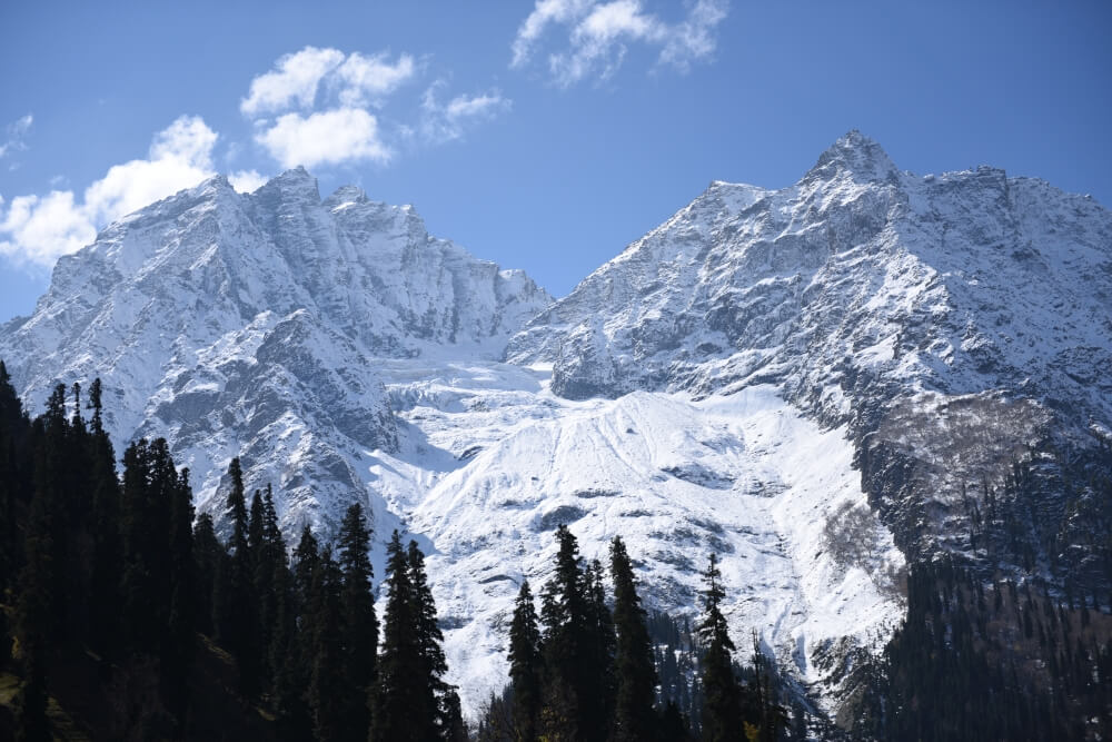
The upper part of the Sindh Valley is one of the finest and most magnificent pieces of scenery in the world. The valley becomes narrow with sheer precipices on either side or the Sindh River, hemmed in and falling steeply, becomes a roaring, foaming torrent. As we emerge from the gorge, we come in sight of the beautiful glacier of crescent terraces and ridges, the outer of which are a mile across. These are the successive terminal moraines of the immense glacier valley of Sonamarg.
The Sindh River, which is also referred to as the Kashmir Ganga in the ancient scriptures emanates from the southern slopes of the Great Himalayan Range and flows in a northwest and then in a southwesterly direction. The volume of water increases, as numerous smaller mountain streams join the river from the north and the south of the valley. The united waters of the river form an impetuous torrent, which flows over a rocky bed. The river initially takes birth in the east from the head wall of Mashran Bal, the mountain barrier which separates Kashmir from the Kishtwar valley.
The principal tributaries here are Nek Nar, Kel Nar and other small tributaries. At Panjtarni, five streams join the budding stream, in a grassy plain. Further west, the Amarnath Nar from the holy cave of Amarnath joins the fledgling rivulet at Sangam, before flowing in a narrow defile towards Baltal. Short of Baltal at Domel, it is joined by the Hiurbagwan stream. At Baltal from where the Sindh valley broadens and takes a beautiful shape, it is further joined by the Zojipal Nar from the north. From here the river fans out towards Sonamarg and flows in all its splendor. Between Sonamarg and Gagangir, the river passes through the Gagangir gorge, under the shadow of precipitous heights and grey cliffs of the Sogput Dhar which towers, some 1524 m to 2439 meters above the river. This is the upper Sindh valley. The river after Gagangir flows via Kangan to Ganderbal, the principal townships of the middle and the lower Sind valley, respectively. After Ganderbal, towards its confluence with the Jhelum, the river fans out in multiple channels and forms an extensive delta. The river here onwards becomes navigable and the Hanjis operate in their dungas and shikaras. It partly flows into the numbal and then on, into a lake on the outside of Srinagar called Anchar. It finally joins the Jhelum in a single channel, at its western extremity opposite the village of Shadipur, after covering a distance of over 96 km.
Historically, the Sindh valley was traversed by all the invaders coming from the north. Ranchen Shah, the Turk invaded Kashmir in the fourteenth century, which led to downfall of the Hindu rule in Kashmir. Mirza Muhammad Haidar, with his small band of Mughals also successfully fought his entrance into Kashmir in 1532 AD. More recently, the Indian Army after moving up the Sindh valley captured this strategic pass from the Pakistani Raiders on Nov.1, 1948, after launching ‘Operation Bison’.
The Sind valley is a revered valley, with many sacred sites designated as Tirthas and worshipped as gods, from ancient times. Of particular significance, at the head of the valley lies the Amarnath group of peaks, with the highest summit at 5280 m. Dedicated to Soami Shurji or Lord Shiva, the mountain towers above the holy cave and the Amarnath Nar.
Unprecedented cloudbursts in the upper Sind valley in 2015 and 2014 extensively damaged human habitat and the communication network. While the summer maximum temperature in 2015 reached 25° C, winter temperatures in the inhabited areas plummeted to -20° C. Sarbal and Nilgrar, the last inhabited villages ahead of Sonamarg en route to Ladakh are migratory villages, which too are vacated in winter.
As per 2011 census, the total population of the Sindh valley was approximately 121000. Apart from Kashmiri, Urdu, Balti, Shina, Gojri and Pahadi languages are spoken.
The Sindh Valley has a thick forest cover also called Sindh Forest. While the upper reaches are bare, with the tree line finishing at 3350 m, the margs are beautiful, widespread and the alpine forest evergreen. Agriculture and livestock rearing are the primary occupations in the Sindh valley. Almost 80% of the population is engaged in agriculture.
The temperate climate of the Sind valley from its origin to its confluence permits cultivation of a variety of fruits and vegetables. The leafy and root vegetables are grown in abundance. It is rightly said that, if Kashmir is a country of fruits, then the Sindh valley is a cradle for horticulture. Mulberry, apple, apricot, cherry, peach, almond and walnut are grown in the valley. Grapes which were once abundant in Kashmir are today found in the few vineyards located at the mouth of the Sindh River.
As elsewhere in Kashmir, the rabi and the kharif crops are grown in the Sindh valley. The rabi or the spring crop ripens by July and kharif by about by mid – or early October. Rice is the principal crop, which is grown in terraced fields upto 2134 m. Maize is the next important crop. Wheat, barley, millet, pulses and buckwheat are also grown in the upper reaches of the Sindh valley.
The geology of the Sind river valley primarily comprises of a mixture of rocks. The metamorphic rocks formed near Kangan and Wangat comprise a coarse genesis associated with grey sandstones and beds of limestone, some of which are white and high crystalline and some blue and scarcely altered16. At Sonamarg in the upper Sindh, the river cuts through a barrier of igneous rocks, which are weathered and firm, running northwest to southeast.
The vast area of the Sindh valley and its thick forest area is rich in Himalayan fauna. The forests of Sindh abound with the Bengal monkey. Large numbers of the Himalayan langur, bright and reddish in color can be seen in the valley. The leopard and the Snow Leopard, are found in the upper parts of the valley. The jackal and the Common Fox are found in the lower Sind valley.
The upper reaches of the Sind valley are also inhabited by bears, namely the Black Bear. The Brown or Red Bear, is found in good numbers. The ibex also inhabits the upper Sindh towards Zojila and Bot Kulan Ganj along with the mountain goat. The Barasingh or Hangul, the Kashmiri stag and the musk deer, also inhabit the valley.
The Sind valley epitomizes the natural beauty and versatility of Kashmir. Nowhere is the balance of a traditional way of life and the ‘developmental transition’ more visible than in this valley. However, the natural environment of the Sindh River is under threat today – a matter of grave concern. Increased human population and consequently, the human footprint and habitat has put enormous pressure on the limited resources and carrying capacity of the valley. Global warming, coupled with an increasing influx of tourist and vehicular traffic has further accentuated the problem. Rapid commercialization and construction, as a result of increased economic activity and development, has led to rising ambient temperatures. Thawing glaciers have increased water levels in the rivers. Deforestation is another major cause; the lower reaches of the valley have been completely denuded of forests. Extensive grazing in the upper reaches and vanishing lowland meadows have given way to concretization, like the virtual disappearance of the golden meadows of Sonamarg, which today is choked by hotels.
As Ernest Frederic Neve (1861-1946), a British surgeon, Christian medical missionary, and author, who provided medical care to the people of Kashmir, has described Sindh Valley as ‘one of the finest and most magnificent pieces of scenery in the world.’
________________
The author is a senior journalist and Chief Editor, Sindh Courier.
Source of the notes: Greater Kashmir, Ganderbal, Better Kashmir, Rising Kashmir, Flicker, Ethno Botany Journal, Niva Link, Kashmir Life, Kashmir Observer, Himalayan Club, Wikipedia Sindh River, Wikipedia Sindh Valley etc.