Sitting on a Volcano
Like rest of the country, the people of Sindh too are virtually sitting on a volcano that can erupt anytime and cause catastrophic situation.
Pakistan lies in an active seismic region and is frequented by earthquakes of varying magnitude. Major parts of the country are jolted even by the earthquakes occurring in neighboring countries.
Global warming won’t just change the weather—it could trigger massive earthquakes and volcanoes.
Nasir Aijaz
Like rest of the country, the people of Sindh too are virtually ‘sitting on a volcano’ that can erupt anytime and cause catastrophic situation. I have used the phrase ‘sitting on volcano’ in view of the frequent earthquake jolts occurring in this region. It’s not me who says this, but anyone can conclude after going through the global reports on geological and seismic conditions of this region as well as the media reports on frequent earthquake tremors having taken place in Sindh in the past and recently.
The threats of such natural disasters are more eminent as the international experts are of the opinion that the earthquakes could be the result of climate change or the shaking of earth might be one of the consequences of climate change.
Pakistan lies in an active seismic region and is frequented by earthquakes of varying magnitude. Major parts of the country are jolted even by the earthquakes occurring in neighboring countries, like that one in Afghanistan a couple of days back that killed about one thousand people in that country.
While the global reports also suggest that the Karachi – the capital city of province sits close to a plate boundary and within reach of earthquakes on numerous tectonically active structures surrounding the city, so is the case with other parts of Sindh where a number of earthquake tremors have been reported in the recent past besides major jolts in certain parts as mentioned in the history of earthquakes.
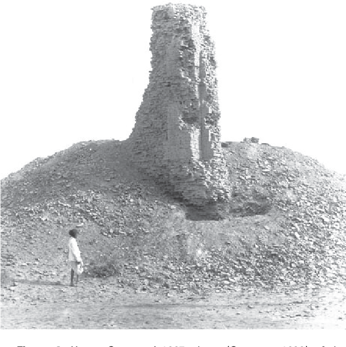
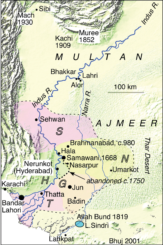
According to historical record, one of such major earthquakes is said to have taken place on May 5, 1668 AD when Shahbandar town in coastal belt of Sindh was destroyed and some 50, 000 people had died. In another earthquake on June 16, 1819, in Allahbund area some 1543 people had died. The Shahbandar earthquake was of 7.6 magnitude and the other one was of 7.7 and 8.2 magnitude.
In certain cases, tremors in Karachi and other southern parts of Sindh have often been felt due to earthquake having epicenter in bordering Indian region. The people of Sindh have not forgotten the powerful tremors measuring 6.5 on the Richter scale that hit the entire province at about 8.20a.m on January 26, 2001. Some 15 people were killed and another 108 injured in the earthquake. The epicenter was somewhere in India. The earthquake tremors measuring 3.5 magnitude had also jolted Sindh’s coastal belt including Badin, Thatta and Karachi’s Malir and Landhi areas. Again the powerful tremors had jolted Karachi and other districts in 2005 and 2013.
According to a report on history of earthquakes in and around Karachi since the year 1900 AD, the 8 quakes were of above magnitude 5; 39 quakes between magnitude 4 and 5; 10 quakes between magnitude 3 and 4.
 One of the recent earthquake of magnitude 4.1 was 56 km West of Hyderabad few months ago. The earthquakes having taken place in recent pat at different times are: Badīn District, Sindh, Awaran, Balochistan, District West Karachi, Hyderabad, Jāmshoro, Karachi Central District, Karachi East District, Karachi South District, Khuzdār Balochistan, Korangi District of Karachi, Lasbela, Malir District of Karachi, Matiāri, Sujawal, Sānghar, Tando Mohammad Khan District and Thatta districts of Sindh.
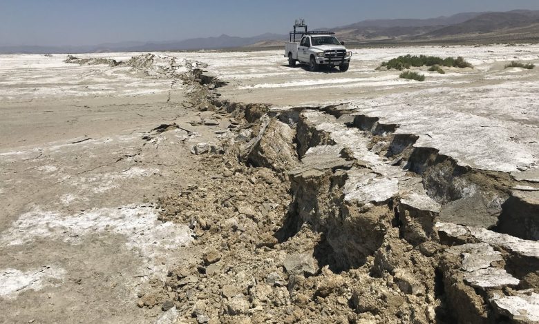
Another powerful earthquake had shaken most of Sindh on May 21, 2022. The jolts originated from Dadu district that shook the neighboring districts and most parts of the province at around 10a.m.
According to National Seismic Monitoring Centre (NSMC), the earthquake originated 33 km southwest of Dadu. The depth of the earthquake was 15 km and its magnitude on the Richter scale was 3.9.
No loss of life had been reported after the earthquake. However, the jolts that are relatively closer to the surface are likely to bear long-term adverse effects on the property, a report said.
The earthquake lasted for several seconds, causing fear among citizens who were forced to step out of their homes in the scorching heat.
Earlier, on December 9, 2021 at 11.59a.m., an earthquake of magnitude 4.1 hit Karachi. It occurred 15 kilometers south of Defense Housing Authority (DHA), Karachi, according to Pakistan’s National Seismic Monitoring Centre. Tremors were reported in North Nazimabad, Nazimabad, Baldia, Quaidabad, Scheme 33, Gulshan-e-Iqbal, Gulistan-e-Jauhar, Gulshan-e-Hadeed, and other parts of the city. The earthquake of this magnitude in Karachi shocked the relevant authorities as they have never recorded such a powerful earthquake whose epicenter was within the provincial capital.
A day earlier, on December 8, 2021 also earthquake tremors were felt in Karachi, according to the Pakistan Meteorological Department. Tremors were felt in Gulshan-e-Iqbal, Gulistan-e-Jauhar, Malir Cantt, Scheme 33, and I.I. Chundrigarh road, Gulshan-e-Hadeed, Gadap Town, North Nazimabad, Keamari, and Federal B Area, while Dhabeji and Gharo of District Thatta were also affected. PMD said that the frequency of the quake was 4.1 magnitude on the Richter scale, and was measured a depth of 15 kilometers. Tremors were felt in the city at 10:16pm, while its epicenter was 15 north of Defense Housing Authority (DHA).
Hardly a month earlier, on November 4, 2021 also the 4.8 magnitude quake hit coastal areas of Karachi. The tremors were felt in New Chali, Pakistan Chowk and other areas. The epicenter was 50 km from Badin and its depth was 17km.
Likewise, the earthquakes were detected in other parts of the region, including Hyderabad. The earthquake was estimated at 4.5 magnitude at Richter scale by India’s National Center for Seismology (NCS) at a depth of 89.6 kilometers under the epicenter in the Sanghar district.
On November 4, 2021, the earthquake measuring 4.9 magnitude had jolted the coastal area of Jati Taluka of Sujawal district. Its depth was said to be 10km. The jolts were felt 22km southeast of Jati.
Minor earthquake jolts were also reported from Shikarpur, Mirpurkhas, Tando Allahyar, Shahdadpur, Sinjhoro, and Jhol at different times. The tremors were also felt even in Dhoro Naro.
 Unpreparedness, Uncertain Past and Uncertain Future
The government authorities in Pakistan in general, and Sindh in particular, seem to be far from ‘preparedness’ required in the wake of such unforeseen situations. National Disaster Management Authority (NDMA) was established at federal level only after the 2005 earthquake that had devastated areas in Khyber Pakhtunkhaw and Azad Kashmir and killed around 80, 000 people. Such organizations were established at provincial level and Provincial Disaster Management Authority (PDMA) Sindh was one of them. Again, the PDMAs were to setup District Disaster Management Authorities so that immediate rescue and relief operations could be launched in case of such disasters. But unfortunately, PDMA Sindh has failed to setup its network at district level even after seventeen years. It is said that the PDMA Sindh has posted few officials who use to sit at district administration’s offices in each district with no active role. It has maintained only a website and issues mere advisories in case of expected rains and undertakes distribution of relief goods among the flood affected persons amidst corruption scandals. The PDMA could be termed as an organization that is lacking required preparedness, having no historical record, seismic data etc.
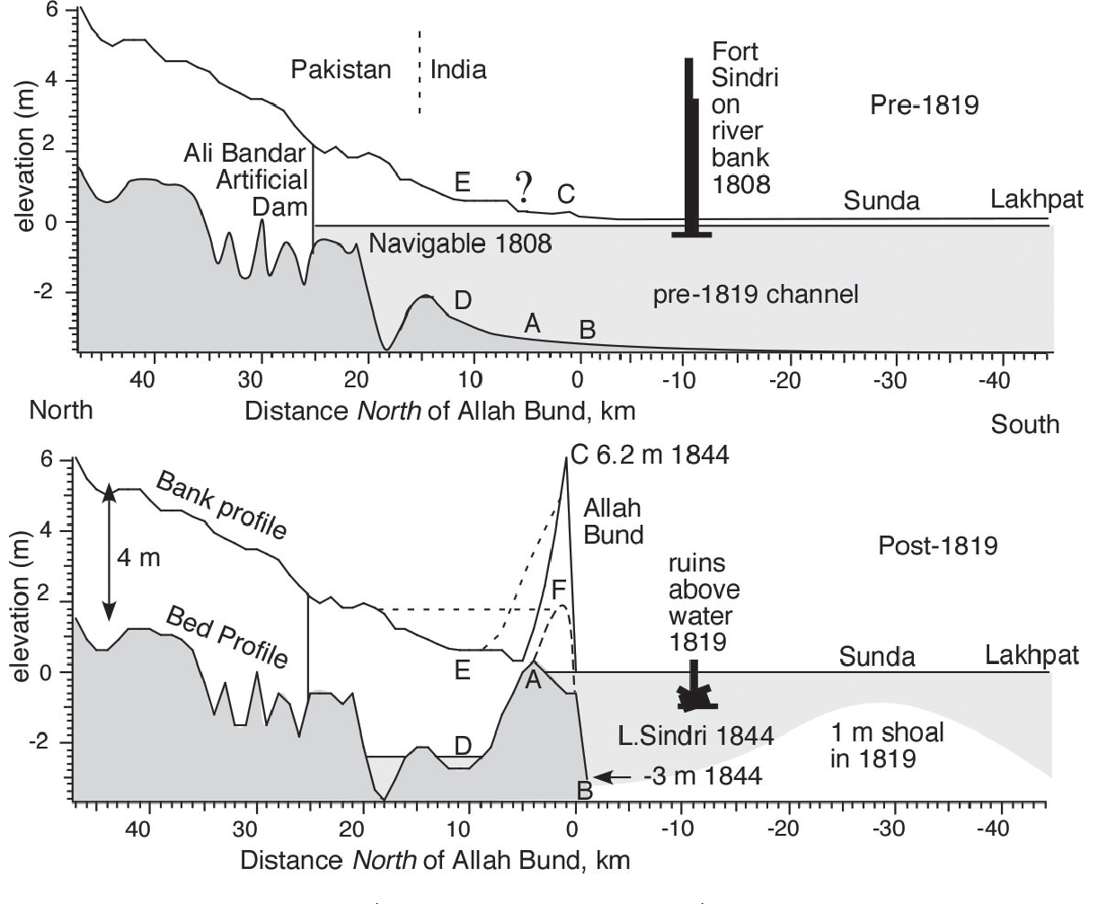
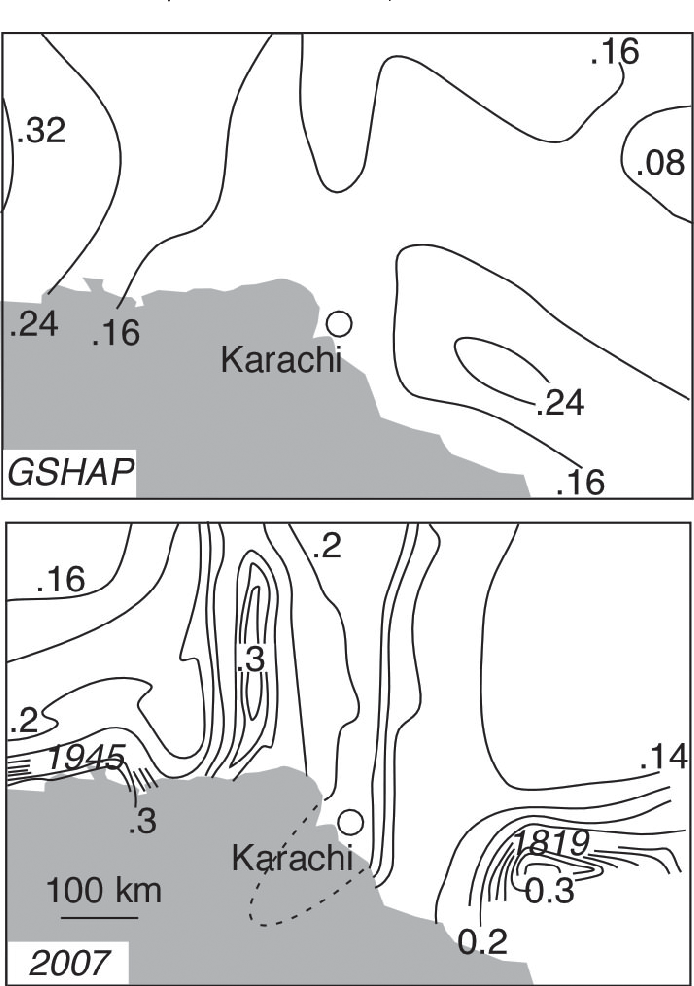
I will refer here a research report which sheds light on the prevailing situation. R. Bilham S. Lodi, S. Rafeeqi and some other researchers in their joint research paper titled ‘Seismic Hazard in Karachi, Pakistan: Uncertain Past, Uncertain Future’, published in November 2007, had stated that with a short historical record, limited instrumental seismic data, and little geological or geodetic constraint on slip rates, seismic hazard in Karachi is poorly characterized.
In their report they presented a critical review of the historical record as well as an overview of potential earthquake sources in and around Karachi.
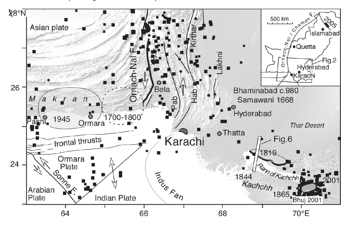
 The report says that the Karachi lies approximately 150 km east of the triple junction between the Arabian, Indian, and Asian plates. A recently discovered active fault – the Sonne fault, indicates that the Arabian plate has been fragmented across the southwest corner of the triple junction defining a triangular plate. In addition to these clearly defined plate boundaries, two other active structural zones have produced damaging earthquakes that have been felt in the city in the past 200 years: a thrust-and-fold belt extending northward parallel to the transform fault separating India from Asia, and the Kachchh fault system trending westward toward the city.
Although residents of Karachi felt shaking from the 1945 Makran and 2001 Bhuj earthquakes, and occasional shaking from M 4–5 earthquakes on faults north and northwest of the city, no earthquake has ever produced documented damage in Karachi. The question currently faced by earthquake engineers is whether Karachi truly enjoys an aseismic setting or whether the absence of damaging earthquakes is only due to Karachi’s short and incomplete history. A review of the known historical data on earthquakes within 500 km of the city shows that the historical record prior to 1800 is limited and unreliable.
Karachi has experienced no earthquake related damage in the recorded history of past 175 years. Yet, Karachi is located in a seismically active tectonic setting often compared to Los Angeles with active plate boundary faults and triple junctions within a radius of 150 km. This discrepancy in earthquake history and seismotectonic setting has led to diverse seismic hazard assessments for Karachi ranging from assignment of seismic hazard zones I (least severe) to IV (most severe).
Based on latest seismicity data from the Karachi Arc and illuminates recent activity within the Karachi metropolitan area, the research says that since the epicenter locations cover the entire Karachi Arc, the whole structure seems to be currently active with hypocenters located in a depth range of (0-500) kilometers. Most of these, however, are shallow (10-50 kilometers). Many of the epicenters are located within or near the Karachi neighborhoods plagued by recurrent earthquake activity. That explains why the people are so tormented. Coastal areas in southern Karachi are also exposed to tsunami threats from earthquakes along the shorelines or from within the Arabian Sea.
This study also provided the first outcrop evidence of wrench nature of the southern boundary of Karachi Arc. The photographed fault, named Makli Fault here, is located 2 kilometers south of Makli (about 6 kilometers southwest of Thatta) in the Sindh province and appears to be part of a system that extends westwards through Karachi, where it is hidden under the concrete and urban sprawl. Geomorphic observations suggest that faults belonging to this system might have locally deflected the Malir and Lyari River channels and also created accommodation space for deposition of such coarse clastics as the Korangi Conglomerate. Progressive folding and shear-related drag – along the southern wrench boundary of Karachi Arc – as it moved eastward during the Neogene – probably resulted in the formation of large SW plunging folds such as the Monghopir anticline and the adjacent syncline. The limbs of both of these folds are also torn by prominent NW oriented Riedel shears with enhanced drag-related wrench offsets. More fieldwork is urgently needed to map active faults in Karachi and develop a better understanding of the tectonic threats.
 Linking Earthquakes with Climate Change
Climate change can lead to flooding, hurricanes, droughts, wildfires and habitat loss. But could it also be shaking the ground beneath our feet?
The debate around the connection between climate change and earthquakes has been almost as intense as the earthquakes themselves. When professor Bill McGuire released his book “Walking the Giant: How a changing climate triggers earthquakes, tsunamis and volcanoes,” in 2012, it was deemed to be “science fiction,” according to an article in the British national newspaper The Sunday Times by journalist and climate skeptic Jeremy Clarkson. However, by looking more closely at the evidence, McGuire’s work begins to gain some credibility.
There are lots of myths about earthquakes. A common one is that there’s such a thing as “earthquake weather” — certain types of weather conditions that typically precede earthquakes, such as hot and dry, or dry and cloudy. The myth stems from the Greek philosopher Aristotle, who proposed in the 4th century B.C. that earthquakes were caused by trapped winds escaping from subterranean caves. He believed the large amounts of air trapped underground would make weather on Earth’s surface before a quake hot and calm.
The atmosphere, the ocean, and the ground beneath our feet are all part of the Earth system. They interact with each other, and a perturbation in one can lead to a change in another. The layer of gases that produces the weather and triggers climate change does affect our land, which is referred to as the geosphere. Earlier, in 2009, in a paper by Chi-Ching Liu and his colleagues partially explained the relationship between climate change and earthquakes. Liu and his team provided reliable evidence for a pattern between typhoons and small earthquakes that were shaking the island. They argued that the low-pressure centers of these typhoons allow earthquake faults within the crust to move and release accumulated strain.
Again in August 2016, a Nepalese columnist Jayanta Basu raised this question. The Nepal was devastated by severe earthquake in 2014.
“An earthquake is building up under the Gangetic delta, which could possibly be linked with the rapid rise in global temperatures leading to climate change,” Basu had quoted Kolkata-based geographer Sujib Kar, as saying.
“The relationship between temperature rise and rise in number of earthquakes is evident from two sets of data documented over a period of time,” Kar had said. “If you look at the number of earthquakes of 5 or more in Richter scale from 2001 to 2015 in earthquake-prone areas, you will be able to comprehend the dynamics. This has been the period when the rise of global temperature was phenomenal.”
Global warming has been “increasing seismicity and probability of earthquake,” Kar said, who teaches in Vidyasagar College, Kolkata, in a paper ‘Impact of global warming on the probable earthquake in the Bengal basin area with respect to the global scenario’, which was published in the International Journal of Engineering Science Invention.
Kar says the total number of earthquakes of 5 or more on the Richter scale across the globe in 2001 was 157. This has increased nearly ten times in a decade and half to 1,556 in 2015, with almost all the continents showing a rising trend.
 In November 2021, Meteorologist Dr. Mario Picazo warned in his report that the changes in the landscape are putting an increased stress load on the Earth’s crust, which scientists say has been correlated to seismic activity.
The researchers around the world have continued working on this question. In December 2021, three researchers – Bikash Sadhukhan, Shayak Chakraborty and Somenath Mukherjee published their paper ‘Investigating the relationship between earthquake occurrences and climate change’ in Arabian Journal of Geosciences.
According to them, global temperature is a major climate variable that has a wide impact on the Earth’s ecology and civilization. Global temperatures have also progressively risen as a result of the industrial revolution and urbanization. The correlation between earthquakes and rising global temperatures has been proposed before but has not been empirically verified. However, their study signifies the existence of a strong correlation between the magnitude of earthquakes and global temperature fluctuations.
The researchers have not neglected the other aspect – the climate change is triggered by the volcano eruptions and earthquakes.
Peter Sousounis, in a report published by a world organization – Air Worldwide, “Melting glaciers and thermal expansion of oceans from climate change may also contribute to another earthquake-related hazard. Rising seas are raising the water table in many places of the world, which can translate to an increased tendency for liquefaction during earthquakes.”
He further says, “Earthquakes in the Himalayas have been linked to heavy rainfall in the region. During monsoon season, the addition of water weight reduces micro-seismic activity and in the dry season it is enhanced (Panda et al. 2018). The extra weight causes plates to move horizontally as well as vertically.”
Another researcher Ilan Kelman argued on Prevention ‘Web’ that ‘volcanic eruptions have affected the climate throughout the eons. If eruptions are big enough, their emissions circle the globe and block some sunlight for a few years, which can cool the climate. After Mount Pinatubo erupted in the Philippines in 1991, the world had a short period with a small cooling effect, before human-caused climate change took over again.
On a question if the climate change affecting earthquakes and volcanic eruptions? The researcher said, “Sea-level rise from climate change is a possible influence on tectonic processes. Differences in sea level redistribute the amount of seawater over fault lines, changing earthquake frequencies and other traits. Similarly, the pressure from water over an undersea volcano affects eruption frequency and some aspects of eruption magnitude.
“So, yes, tectonic processes change the climate and climate change affects earthquakes and volcanic eruptions—in many ways, over many timespans, and over many extents in area. This intricate dance among the land, ocean, and atmosphere is not surprising. Irrespective of scientific specialization, we know how inextricably all aspects of the planet are interconnected.
The key is avoiding adverse effects of these changes on another major part of the Earth: Life including human beings, the researcher concludes.
_______________
Author is senior journalist and Chief Editor of Sindh Courier. He can be accessed at nasiraijazpk@yahoo.com
Source: Semantic Scholar, Volcano Discovery, Carbon Brief, The Third Pole, The Weather Network, QZ&A, Prevention Web, Springer Link, Earthquake, Geo TV, ANI News, Knowledge Bazaar, Earthquake Live, Medical News, Earthquake Zone, Pro Pakistani, NUSCIMAG, NASA-Global Climate Change, Verisk (Air Worldwide) and other websites.