

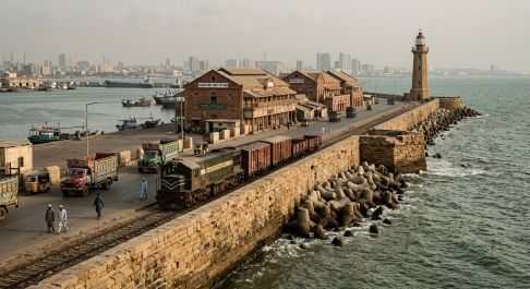
They developed harbour channels, breakwaters, groynes, wharves, piers, lighthouses, telegraph stations and coastal communications.
By Ramesh Raja
British maritime engineering in the territory that became Pakistan was concentrated principally along the Sindh coast and the coast of British Balochistan. After occupying Karachi in 1839 and annexing Sindh in 1843, the British recognized Karachi’s exceptional position as a gateway between the Arabian Sea and the agricultural regions of Sindh and Punjab. They subsequently developed harbour channels, breakwaters, groynes, wharves, piers, lighthouses, telegraph stations and coastal communications.
Their activities also extended westward along the Balochistan and Makran coast, although the nature and scale of the work were very different from Karachi. Gwadar must specifically be excluded because it belonged to the Sultan of Muscat until 1958.
Karachi Harbour and Napier Mole
The first major British coastal engineering work was the Napier Mole, constructed around 1850 to connect Karachi with Keamari across tidal waters and mudflats. It provided a dependable land connection to the harbour and became the foundation for subsequent port development.
From the 1850s, the British also began systematic improvement and dredging of Karachi Harbour. The objective was to overcome the shallow entrance and shifting sediment and create a navigable channel for increasingly larger ships.
Keamari Groyne and Manora Breakwater
The Keamari Groyne was one of the principal harbour-protection structures. It projected into the sea to influence tidal currents and protect the harbour entrance from excessive siltation.
The Manora Breakwater, constructed during the nineteenth century, provided protection from the Arabian Sea and the southwest monsoon. Together, the groyne, breakwater and dredged channel transformed Karachi from a naturally restricted tidal harbour into a major engineered port.
Piers, Wharves and Berths
British engineers subsequently constructed permanent cargo and passenger facilities. The Merewether Pier was completed in 1882, followed by additional wharves, lighterage facilities and berths. By the early twentieth century, Karachi possessed an integrated port system connected directly with the railway network.
The East Wharves, Napier Mole Boat Wharf and later West Wharf provided facilities for loading and unloading cargo. These works enabled agricultural products from the Indus basin to reach international markets and helped establish Karachi as the principal commercial port of the region.
Manora and Cape Monze Lighthouses
Navigation was another major component of British coastal engineering. The Manora Lighthouse guided vessels approaching Karachi Harbour, while the Cape Monze Lighthouse, constructed in 1914, marked the dangerous coast west of Karachi. Pakistan’s Mercantile Marine Department confirms the 1914 date for Cape Monze.
These lighthouses were part of the wider British maritime safety system, which included nautical charts, tide measurements, signalling and navigational information.
Makran Coast: Pasni and Ormara
British involvement in the Makran coast was different from the large-scale harbour development at Karachi. The coast was strategically important because it formed part of the communication route between India, Persia and the Arabian Sea.
The British Government constructed and operated telegraph communications along the Balochistan and Makran coasts during 1860–1867, connecting India towards the Persian Gulf. British archival records specifically document the construction of the telegraph line through Sindh and along the Balochistan and Makran coasts.
Pasni and Ormara served as important coastal settlements and landing points. British administration maintained communications and government facilities in these areas, while their sheltered coastal locations gave them strategic value. In the late colonial period Ormara came under Las Bela State and was within the British political framework of Balochistan.
The 1945 Makran earthquake and tsunami provides further evidence of the coastal infrastructure that existed by that time. Pasni and Ormara were severely affected, with government buildings, postal and telegraph facilities and other infrastructure damaged or destroyed.
About Gwadar
Gwadar should not be counted among British-built coastal works in Pakistan before 1947. Although geographically situated on the present Pakistani coast, Gwadar was a possession of the Sultanate of Muscat and Oman from 1783 until its transfer to Pakistan in 1958. Contemporary British geographical records explicitly described Gwadar as belonging to Muscat and therefore as foreign territory.
British influence existed around the Makran coast, including telegraph communications, but that does not make Gwadar a British-administered port.
The 1945 Tsunami and the Test of British Works
The great Makran earthquake and tsunami of 28 November 1945 provided a severe test of the coastal infrastructure. The tsunami badly affected Pasni and Ormara and also damaged Karachi’s coastal installations. The Manora Lighthouse and Cape Monze Lighthouse were damaged, while parts of Karachi’s harbour protection works were affected.
This event demonstrates that British coastal engineering had to contend not only with tides, waves and sedimentation but also with one of the most powerful natural hazards of the Arabian Sea.
The Maritime Legacy of 1947
By independence, the British had created a substantial maritime infrastructure in the territory inherited by Pakistan. Karachi Harbour possessed dredged navigation channels, groynes, breakwaters, piers, wharves, berths, lighterage facilities, ship-repair arrangements and navigational lights. Along the Balochistan and Makran coast, the British had established strategic communications, telegraph infrastructure and administrative facilities at important coastal settlements.
The British coastal legacy therefore complemented their roads, railways, bridges and irrigation works. Karachi connected the Indus agricultural economy to the world, while the Makran coast formed part of a strategic communications chain extending towards Persia and the Arabian Sea.
On 14 August 1947, Pakistan inherited not simply a port at Karachi, but an interconnected maritime engineering system that had evolved over more than a century. Its foundations would later support the expansion of Pakistan’s national ports, coastal highways, fisheries infrastructure and naval facilities.
Click here to read Part-1, Part-2, Part-3, Part-4, Part-5,
________________
 The author of this article, Engr. Ramesh Raja, is a Civil Engineer, visionary planner, PMP certified and literary enthusiast with a passion for art and recreation. He can be reached at engineer.raja@gmail.com


