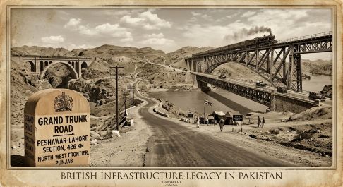
When Pakistan emerged on the world map on August 14, 1947, it inherited an impressive, complex network of steel and stone. From the strategic border passes of the NWFP to the vast plains of Punjab and Sindh, the road and bridge infrastructure built under British rule laid the literal groundwork for the modern nation’s transit backbone. Here is an overview of the historic routes and engineering marvels that shaped Pakistan’s early highway legacy.
By Ramesh Raja
British-Era Roads and Bridges
The road and bridge network inherited by Pakistan on 14 August 1947 was developed over more than a century of British rule. There was no single British officer responsible for all roads and bridges. Political authority rested with the Viceroy in New Delhi and the provincial governments, while construction and maintenance were principally undertaken through the Public Works Department (PWD), headed technically by Chief Engineers, Superintending Engineers and Executive Engineers.
Immediately before independence, Sir Evan Jenkins was Governor of Punjab at Lahore, Sir Robert Francis Mudie was Governor of Sindh at Karachi, Sir George Cunningham was Governor of NWFP at Peshawar, and Sir Geoffrey Prior was Chief Commissioner of British Balochistan at Quetta. At the all-India level, Lord Mountbatten was Viceroy and Governor-General.
The most important early Punjab engineering figure was Colonel Robert Napier, appointed the first Chief Engineer of Punjab. Under him, about 250 engineers and sub-engineers worked on the great Peshawar-Delhi road. The planned metalled road was 563 miles, or about 906 km, including 265 miles, or 426 km, from Peshawar to Lahore.
Part A: Roads
- Grand Trunk Road: Peshawar-Lahore
The Grand Trunk Road was the principal British artery in northern Pakistan. The Peshawar-Lahore section was approximately 426 km, forming part of the wider 563-mile/906-km Peshawar-Delhi road. It carried military, administrative and commercial traffic and required numerous bridges and culverts. The Punjab PWD specifically undertook its improvement after 1849.
- Peshawar-Khyber Pass-Jamrud Road
This strategic frontier road connected Peshawar with Jamrud and the Khyber Pass. It was developed principally for military and frontier administration. Its exact British-era length varies by alignment and historical period, so a single figure cannot safely be assigned.
- Peshawar-Kohat-Bannu-Dera Ismail Khan Road
This was a major south-western frontier communication linking Peshawar with Kohat, Bannu and Dera Ismail Khan. British records identify the Peshawar-Kohat and associated southern frontier roads as important military communications. A consolidated pre-1947 length for the complete corridor is not reliably available.
- Thal-Kurram-Parachinar Road
The Thal-Parachinar route provided access to the Kurram Valley and Afghanistan frontier. It was part of the extensive strategic road program of British NWFP. The individual sections changed over time, preventing a reliable single 1947 length.
- Thal-Tochi-Waziristan Roads
The British developed roads towards the Tochi Valley, Waziristan and military posts including Wana. These roads were principally strategic frontier communications. Their individual lengths are recorded in different administrative reports rather than one consolidated register.
- Peshawar-Hazara-Abbottabad Roads
The Peshawar-Hazara communications connected the frontier capital with Abbottabad and the northern districts. These included numerous subsidiary roads and hill communications.
- Punjab District Roads
Beyond the Grand Trunk Road, Punjab possessed a large network connecting Lahore, Rawalpindi, Jhelum, Gujrat, Sialkot, Wazirabad, Multan, Chiniot, Jhang and other districts. Metalled-road mileage increased from 1,036 miles in 1891 to 5,473 miles, approximately 8,808 km, by 1944.
- Sindh Roads
Sindh inherited approximately 1,039 km of blacktopped roads in 1947. Its principal artery was the Karachi-Reti road, approximately 664 km, forming the predecessor of the later National Highway corridor.
- Balochistan Roads
British Balochistan developed strategic communications from Quetta towards Sibi, Chaman, Zhob, Loralai, Kalat and the Afghan frontier. Exact British-era lengths for individual routes are difficult to establish because later alignments changed substantially. The Quetta-Sibi-Chaman and Quetta-Zhob corridors nevertheless became the basis of later national highways.
Total Roads Inherited
The broader historical road series records approximately 50,367 km of roads inherited by Pakistan in 1947, comprising about 9,809 km of high-type and 40,558 km of low-type roads. A narrower series records about 22,136 km of national and provincial highways. The difference results from different definitions of the road network.
Part B: Major Bridges
- Attock Bridge
Completed in 1883, the Attock crossing over the Indus was one of the most important strategic bridges linking Punjab with NWFP. The railway bridge incorporated a road/subway arrangement for wheeled traffic.
- Lansdowne Bridge, Sukkur
Opened in 1889, this famous steel cantilever bridge crossed the Indus at Sukkur and became one of the outstanding engineering achievements of British Sindh.
- Empress Bridge, Kotri
Completed in 1889, the Empress Bridge crossed the Indus at Kotri and connected Karachi with the interior of Sindh through the expanding railway and road network.
- Khushalgarh Bridge
The British constructed a permanent Indus crossing at Khushalgarh to strengthen the Kohat and southern frontier communications.
- Punjab River Bridges
By 1931, major road bridges existed over the Chenab at Wazirabad and Chiniot, Jhelum at Khushab, Beas near Dera Baba Nanak and Sutlej near Ferozepore, together with numerous smaller bridges and culverts.
The British Legacy in 1947
On 14 August 1947, Pakistan inherited not merely a few famous bridges and roads but an extensive communications system. The documented network amounted to approximately 50,367 km of roads, while Sindh alone possessed about 1,039 km of blacktop roads. The British also left major Indus crossings at Attock, Sukkur and Kotri and hundreds of smaller river, canal and stream crossings.
There is, however, no reliable single national figure for the total number of bridges inherited in 1947. Provincial PWD, railway, military and district records classified bridges differently, and a precise figure would require province-by-province archival reconstruction.
The important historical fact is that Pakistan began its independent highway development with a substantial British-built foundation of roads, bridges and engineering institutions, much of which subsequently evolved into today’s national highway network. (Continues)
Click here to read Part-1,
________________
 The author of this article, Engr. Ramesh Raja, is a Civil Engineer, visionary planner, PMP certified and literary enthusiast with a passion for art and recreation. He can be reached at engineer.raja@gmail.com