Extend Expressways on Liyari and Malir Rivers
Fix River Beds and Traffic Congestion in Karachi

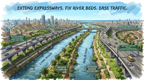
Encroachments on riverbeds, nullahs and drainage corridors have restricted water flows, while unchecked development has placed growing pressure on the city’s roads.
Ramesh Raja
Karachi historically benefited from a natural drainage system that evolved over centuries. Its two major rivers, the Lyari and Malir, together with more than 60 nullahs, carried runoff from the surrounding catchments towards the sea. These waterways supported drainage, sustained local ecosystems and provided essential space for seasonal flood flows.
Rapid and unplanned urban expansion has progressively disrupted this network. Encroachments on riverbeds, nullahs and drainage corridors have restricted water flows, while unchecked development has placed growing pressure on the city’s roads. Untreated sewage, industrial effluent, solid waste and vehicle emissions have further degraded environmental conditions. Karachi now faces the combined consequences of recurring urban flooding, severe traffic congestion and polluted waterways. Settlements within drainage channels remain particularly vulnerable, as the loss of lives during previous floods has tragically demonstrated.
Karachi’s civic history, including the contributions of its Hindu and Parsi mayors, reflects a tradition of attention to municipal services and public spaces. Over subsequent decades, however, inconsistent planning and weakening enforcement allowed encroachments on rivers, nullahs, parks and other public land to become increasingly entrenched.
Restoring these waterways requires the recovery and protection of their natural drainage corridors. Where technically appropriate, roads along their outer boundaries can complement this effort by improving connectivity, providing maintenance access and helping prevent renewed encroachments. Roads and improvement works along Nehr-e-Khayyam, Gujjar Nullah, Korangi Nullah, Chakora Nullah and Mehmoodabad Nullah, together with the Lyari Expressway and Shahrah-e-Bhutto, offer relevant experience for future planning.
Karachi therefore needs a coordinated program that integrates drainage restoration, river protection and transport improvement, with particular priority given to the Malir and Lyari rivers. The guiding principle must be clear: establish the space required for safe river flows first, then design transport infrastructure around it. Roads should protect these corridors without narrowing their channels, obstructing tributaries or transferring flood risks to downstream communities.
Within this framework, the following two projects merit detailed examination.
A). Construction of Shahrah Benazir Bhutto along the Left Bank of the Malir River
The existing Shahrah-e-Bhutto, approximately 39 kilometers long, provides a signal-free connection between Qayyumabad and the M-9 Motorway near Kathore. The Sindh PPP Unit currently lists its project cost at Rs60.7 billion. Building on this connectivity, a complementary multilane corridor, proposed as Shahrah Benazir Bhutto, could extend approximately 40 kilometers along the left bank of the Malir River, from the M-9 near Kathore towards Landhi and Korangi, subject to detailed alignment and feasibility studies.
Suitable interchanges and feeder roads could serve Shah Latif Town, Quaidabad, Future Colony, Mansehra Colony, Landhi, Korangi and adjoining settlements, while giving industrial areas more direct access to the motorway and national highway networks. Connections towards Port Qasim could further facilitate freight movement, reduce the passage of heavy vehicles through congested residential streets and improve journeys for workers and other commuters.
River protection must be a central objective of the scheme. Surveys, land records and hydraulic studies should establish the protected riverbed and the floodplain needed to convey floodwater safely. The road should follow the outer edge of this corridor, with permanent boundary demarcation, adequate drainage openings and measures to prevent encroachment. Its alignment must preserve the river’s flood-carrying capacity while improving access along the industrial and residential belt.
B). Construction of Expressways along Both Banks of the Lyari River from Sohrab Goth to Karachi Northern Bypass (KNBP)
The existing Lyari Expressway, approximately 16.5 kilometers long, was constructed by the National Highway Authority (NHA) at a reported construction cost of approximately Rs10 billion. It provides a signal-free corridor between Mauripur Road and Sohrab Goth, improving connectivity through densely populated parts of Karachi. Extending this facility upstream along both banks of the Lyari River to Karachi Northern Bypass would cover an estimated 17.5-kilometre river stretch, subject to detailed surveys and feasibility studies.
The proposed multilane, access-controlled corridors could serve Abbasi Nagar, Lasi Goth, Ayub Goth, Ahsanabad, the eastern neighborhoods of New Karachi and North Karachi, Surjani Town, Khuda Ki Basti and adjoining sectors of Taiser Town through appropriately located interchanges and feeder roads. Links towards Gadap, Gulshan-e-Maymar, M-9 and the Northern Bypass could improve access for commuters, public transport, emergency services and industrial freight. An effective connection with the existing Lyari Expressway at Sohrab Goth would also strengthen access towards central Karachi, industrial areas and port-connected roads.
Restoration of the Lyari River should form an integral part of this extension. Historical maps, land records, topographic surveys and hydraulic modelling should establish its legitimate boundaries and the floodplain required for safe drainage. Both roads should follow the outer edges of the protected corridor, with sufficient bridge openings and unobstructed tributaries and drainage outfalls. Their combined hydraulic effects must be assessed to ensure that neither the river’s capacity nor the safety of downstream communities is compromised.
Sewage interception and treatment, regular solid-waste removal and measures to prevent renewed encroachment should accompany construction. Public consultation, verified property and occupancy records, and fair compensation and rehabilitation wherever displacement is unavoidable must also form part of project planning.
Together, these proposals offer an opportunity to address Karachi’s transport and drainage needs through a coordinated program. Their success will depend on sound engineering, transparent planning, consistent enforcement and fair treatment of affected communities. Civil society, professional institutions and industry should support and scrutinize this process. Properly planned and implemented, the projects could ease congestion, improve freight movement, reduce flood risks and contribute to a cleaner, safer Karachi.
Read: Debt-Laden Pakistan Leads Borrowing Nations
______________
 Hailing from Gambat town of Sindh, Engr. Ramesh Raja, is a Civil Engineer, visionary planner, PMP certified and literary enthusiast with a passion for art and recreation. He can be reached at engineer.raja@gmail.com